Thematically the SafeLand belongs to Cooperation Theme 6 Environment (including climate change), Sub-Activity 6.1.3 Natural Hazards. The project team composed of 27 institutions from 13 European countries is coordinated by Norwegian Geotechnical Institute (NGI).
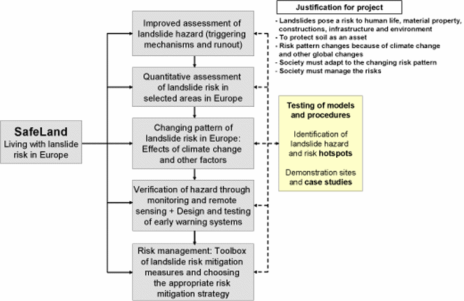
SafeLand will develop generic quantitative risk assessment and management tools and strategies for landslides at local, regional, European and societal scales and establish the baseline for the risk associated with landslides in Europe, to improve our ability to forecast landslide hazard and detect hazard and risk zones. The scientific work packages in SafeLand are organised in five Areas:
- Area 1 focuses on improving the knowledge on triggering mechanisms, processes and thresholds, including climate-related and anthropogenic triggers, and on run-out models in landslide hazard assessment;
- Area 2 harmonises quantitative risk assessment methodologies for different spatial scales, looking into uncertainties, vulnerability, landslide susceptibility, landslide frequency, and identifying hotspots in Europe with higher landslide hazard and risk;
- Area 3 focuses on future climate change scenarios and changes in demography and infrastructure, resulting in the evolution of hazard and risk in Europe at selected hotspots;
- Area 4 addresses the technical and practical issues related to monitoring and early warning for landslides, and identifies the best technologies available both in the context of hazard assessment and in the context of design of early warning systems;
- Area 5 provides a toolbox of risk mitigation strategies and guidelines for choosing the most appropriate risk management strategy.
Maintaining the database of case studies, dissemination of the project results, and project management and coordination are defined in work packages 6, 7 and 8.

Reasons for research
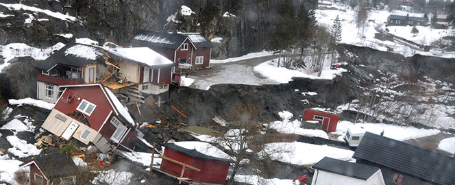
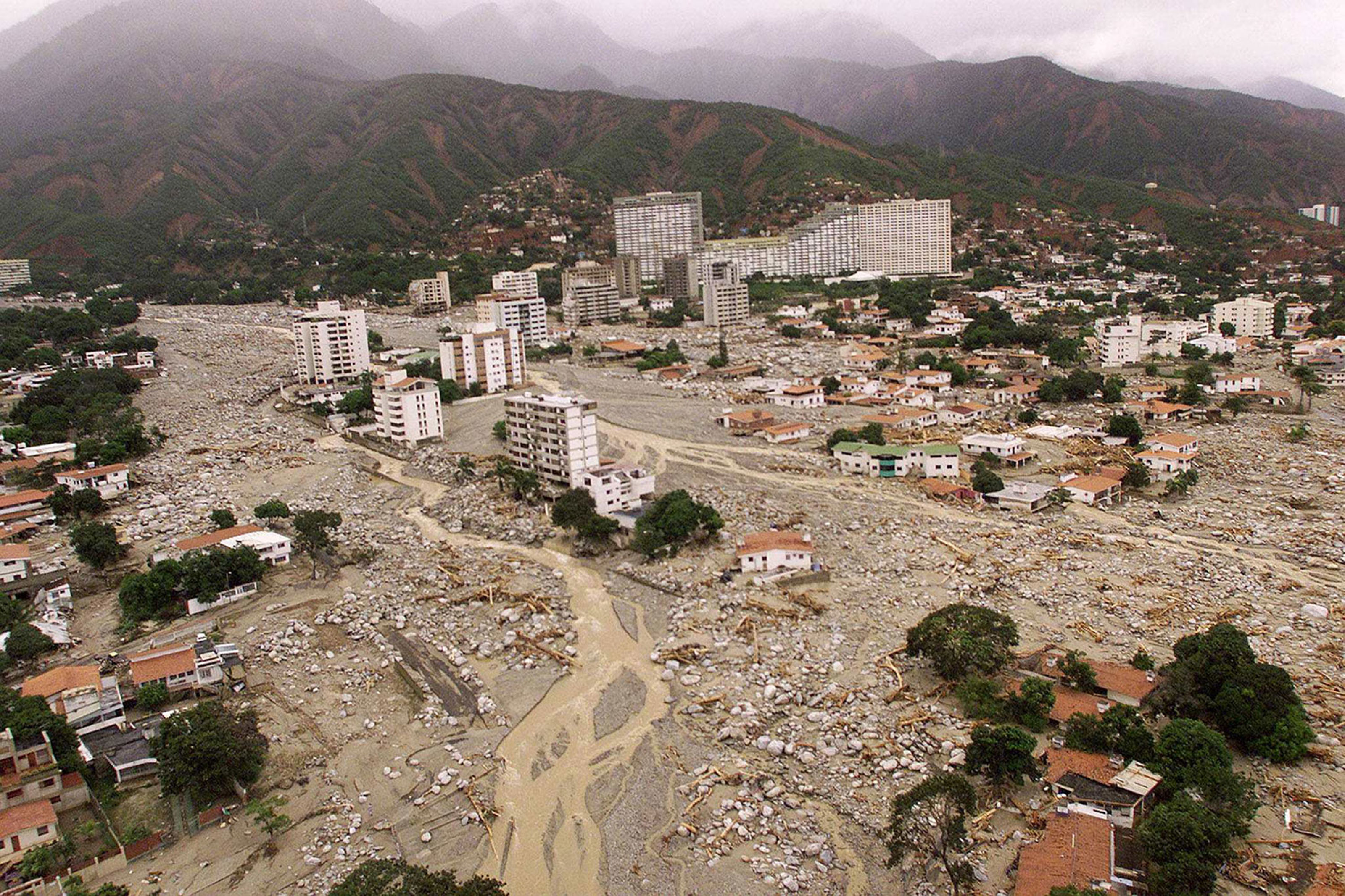
Landslides represent a major threat to human life, property and constructed facilities, infrastructure and natural environment in most mountainous and hilly regions of the world.
Statistics from The Centre for Research on the Epidemiology of Disasters (CRED) show that, on average, landslides are responsible for a small percentage of all fatalities from natural hazards worldwide. The socio-economic impact of landslides is underestimated because landslides are usually not separated from other natural hazard triggers, such as extreme precipitation, earth-quakes or floods. This underestimation contributes to reducing the awareness and concern of both authorities and general public about landslide risk.
In the last century, Europe has experienced the second highest number of fatalities and the highest economic losses caused by landslides compared to other continents (see figure below): 16,000 people have lost their lives because of landslides and the material losses amounted to over USD 1700 M in Europe during the 20th century. Within Europe, Italy has been the country that has suffered the greatest human and economic losses due to landslides. The actual casualty figures shown below are likely to be greatly underestimated in the EM-DAT because events with less than 10 persons killed are not reported. Furthermore, the number of people affected by landslides is much larger than reported: in Italy, while about 500 people have been killed by landslides over the past 25 years, the total number of persons impacted is 50 times that number.
As a consequence of climate change and increase in exposure in many parts of the world, the risk associated with landslides is growing. In areas with high demographic density, protection works often cannot be built because of economic or environmental constraints, and is it not always possible to evacuate people because of societal reasons. One needs to forecast the occurrence of landslide and the hazard and risk associated with them. Climate change, increased susceptibility of surface soil to instability, anthropogenic activities, growing urbanisation, uncontrolled land-use and increased vulnerability of population and infrastructure as a result, contribute to the growing landslide risk. According to the Thematic Strategy for Soil Protection (COM232/2006), landslides are one of the main eight threats to European soils.
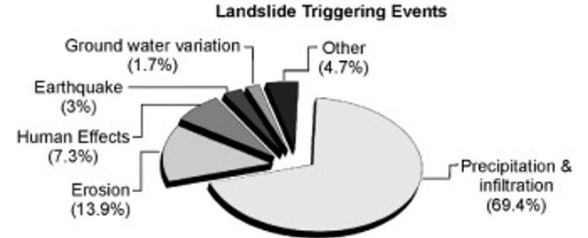
Water has a major role in triggering of landslides. The figure below shows the relative contribution of various landslide triggering events factor in Italy. Heavy rainfall is the main trigger for mudflows, the deadliest and most destructive of all landslides.
Many coastal regions of Europe have cliffs that are susceptible to failure from sea erosion (by undercutting at the toe) and their geometry (slope angle), resulting in loss of agricultural land and property. This can have a devastating effect on small communities. For instance, parts of the north-east coast cliffs of England are eroding at rates of 1m / yr.
As a consequence of climatic changes and potential global warming, an increase of landslide activity is expected in the future, due to increased rainfalls, changes of hydrological cycles, more extreme weather, concentrated rain within shorter periods of time, meteorological events followed by sea storms causing coastal erosion and melting of snow and of frozen soils in the Alpine regions.
The growing hazard and risk, the need to protect people and property, the expected climate change and the reality for society in Europe to live with hazard and risk and the need to manage risk are the reasons for the project consortium to carry out the SafeLand Research.


Number of fatalities (left) and cost of damage (right) caused by landslides 1903 to 2004. Source: EM-DAT – The OFDA/CRED International Disaster database.

Landslide triggers in Italy. (Source: CNR-GNDCI AVI Database of areas affected by landslides and floods in Italy)


