Follow this link to the ChEESE project website
Modelling Earth Systems requires complex models with very high resolution, to accurately model processes which happen over a wide range of spatial and time-scales. Numerical simulations of earth processes therefore require large computational resources. Scientists and engineers who create and use models of geophysical phenomena need more than ever before to collaborate closely with computer scientists to make the numerical models exploit the available computer hardware – to run large-scale models as fast as possible.
Programs which address the most challenging problems in geophysical modelling must be designed to run efficiently on clusters of many thousands of cores.
The Exascale barrier, computers which can perform a quintillion (a billion billion) calculations per second, is likely not far away now. The ChEESE project is upgrading and testing a suite of flagship numerical codes covering a wide range of geoscientific applications to meet this challenge. These codes are being tested and run on some of the largest supercomputers in Europe.
In addition to the design and testing of programs which can run exceptionally fast, the ChEESE project has a heavy focus on the design of robust and efficient workflows that allow the programs to fulfil their objectives and deliver useful results to the end-user.
High Performance computing to simulate local tsunami hazard
NGI is involved in two so-called Pilot Demonstrators in the ChEESE project, focusing on the hazard presented by tsunamis:
- Probabilistic Tsunami Hazard Analysis
- Probabilistic Tsunami Forecast.
See more information about these two aspects under "Sub-projects"in the menue line above. This work is performed in collaboration with several partners, in particular INGV in Italy and the University of Malaga in Spain.
Tsunamis pose a formidable hazard, but one that occurs relatively infrequently. The very low number of historical tsunamis for which sufficient data exists is all the more a reason to increase our understanding of the hazard using numerical simulation.
Tsunamis are long water waves caused by other large natural hazards such as earthquakes, landslides, and volcanoes. They present a threat to near-coastal populations and infrastructure. In ChEESE, new ways of quantifying tsunami hazard will be developed. The main aim is to utilize large High Performance Computing resources to map the tsunami inundation hazard at very high resolution while, at the same time, estimating the large uncertainty associated with tsunamis.

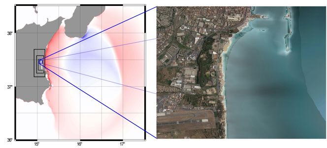
Left, simulation of a tsunami propagating from the Calabrian Arc towards southern Italy. Right, tsunami inundation using a high-resolution map towards an area offshore Catania, Italy. In ChEESE, we will use High Performance Computing to simulate thousands of these kinds of scenarios and use these to represent the coastal tsunami hazard at high resolution.
- Tsunami hazard analysis tells us how probable it is for an area to be inundated by a tsunami of a given size. Tsunamis of moderate run-up height inundating smaller areas are considered more frequent, while tsunami with high run-up inundating large areas are less frequent.
The frequency of the tsunamis is tightly linked to the frequency of their sources. The most common source is earthquakes.
- The uncertainty related to the occurrence probability of any tsunami source is large. Because tsunamis are too infrequent to use data directly to represent the hazard, we need models to do it. To cover the source uncertainty, we need to model tsunamis due to many, often tens to hundreds of thousands of sources. For this, we need High Performance Computing resources.
- The most elaborate tsunami hazard analyses are carried out on a regional level, and hence are not sufficiently accurate for modelling inundation. In ChEESE, High Performance Computing allows us to model tsunami hazard at high resolution using a sufficient number of potential tsunami sources. Using exascale computing, we can combine a rigorous representation of the tsunami uncertainty with high resolution inundation maps. This will form the background for a next generation of tsunami hazard maps with higher accuracy and better uncertainty representation than is possible using today's methods.


